
STORM CHASE!
FOR SEVERAL YEARS, I HAVE BEEN INVOLVED IN STORMCHASING. PART BUSINESS BUT MOSTLY HOBBY, I HAVE CHASED
FOR KTUL-TV CHANNEL 8 AND KJRH-TV CHANNEL 2 IN TULSA, AND NOW CHASE FOR KOKI FOX23 IN TULSA.
MOST OF MY CHASING HAS BEEN WITH JON SLATER AND TAFT PRICE, BOTH TULSA TELEVISION METEOROLOGISTS. MY VIDEO HAS BEEN SHOWN ON KTUL-TV, KJRH-TV,
KOKI FOX23, KSHB-TV IN KANSAS CITY, ABC GOOD MORNING AMERICA, CNN, AND THE WEATHER CHANNEL. ALL PHOTOS ON THIS PAGE ARE ©2002 DAVID J.
WILLIAMS.
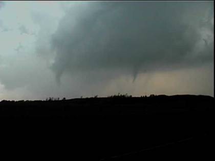
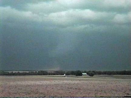
Along with Meteorologist Taft Price, I witnessed a
series of tornadoes touch down near and in Carrier, OK. Taft and I planned this
particular chase for several days, and it did not
disappoint. Unfortunately, though, the small Garfield County town suffered significant
damage in Oklahoma's first major tornado episode
of 1999.

APRIL 21, 1999 –
CARRIER, OKLAHOMA
(TAFT PRICE/DAVID WILLIAMS)
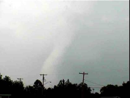
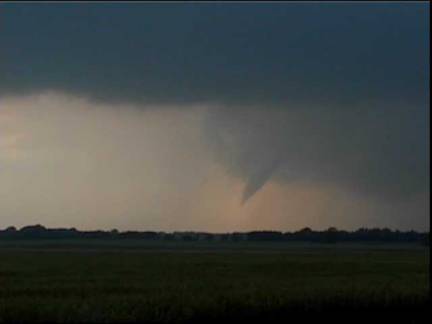
From simply one of my best chases, this is
one of several tornadoes in Alfalfa and Grant Cos., Oklahoma, in
May 1998. I figured that this was the time to get reasonably close to a tornado
if I was going to do so, and this is looking northwest approximately 500 yards.
At the time of this photo, the tornado was located near Byron, Oklahoma.

MAY 28, 1998 –
BYRON,
OKLAHOMA
(DAVID WILLIAMS/THOMAS WILLIAMS)
Meteorologist Taft Price and I planned an
attack early Sunday morning and departed for Medicine Lodge around noon. The dryline appeared on queue during the late afternoon just
east of Medicine Lodge, and an eruption of storms followed. Taft and I
witnessed several small tornadoes in Kingman County, including rare side by
side twisters.
MAY 15, 1999 –
KINGMAN COUNTY,
KANSAS
(TAFT PRICE/DAVID WILLIAMS)
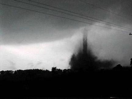
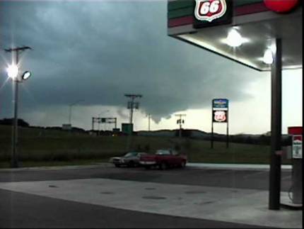
On June 1,
1999 a cold front/trough pushed into an explosive eastern Oklahoma atmosphere. I proceeded
eastward along the boundary after a tornado watch was issued mid-afternoon. I
captured the below image of a tornado in Muskogee, OK as it ripped through the
OG&E Power Plant.
JUNE 1, 1999 –
MUSKOGEE,
OKLAHOMA
(DAVIDWILLIAMS)
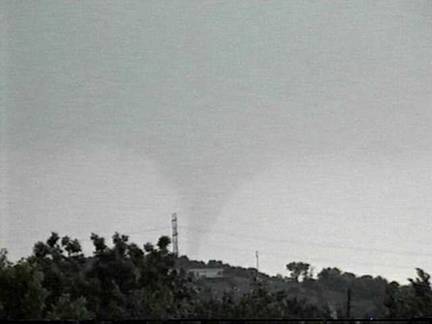
Another tornado from May 28, 1998 – this one was near Wakita, Oklahoma, and was about 300 yards
distance at the time of this photo.
MAY 28, 1998 –
WAKITA,
OKLAHOMA
(DAVID WILLIAMS/THOMAS WILLIAMS)
This tornado occurred as part of a tornado
outbreak over eastern Oklahoma
on Memorial Day, 1997. At the time of the photograph, the tornado was located
south of SH 116 between Sapulpa
and Glenpool, Oklahoma.
The tornado was rated F2, and was the first tornado ever imaged by Doppler on
Wheels. Shortly afterwards, my camcorder ceased to operate.
MAY 26, 1997 –
SAPULPA,
OKLAHOMA
(JON SLATER/DAVID WILLIAMS)
Was it a tornado or wasn't it? Well, I
think it was, but this funnel near Wheeler, Texas
was never officially logged as a tornado. The dust below the condensed feature
was rising into the updraft, and it appears to have been a weak tornado.
MAY 1997 – WHEELER, TEXAS
(JON SLATER/DAVID WILLIAMS)
This large funnel was never officially
logged as a tornado, but nonetheless was well-defined and condensed almost to
ground level. Another interesting feature of the image is the rainbow to the
left of the funnel. This photograph was taken east of Morris,
Oklahoma.
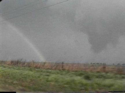
MAY 8, 1998 –
MORRIS,
OKLAHOMA
(JON SLATER/DAVID WILLIAMS)
April
19, 2000 was a very complex day meteorologically. A
deep surface low was located in northern Missouri
with a warm front extending ESE toward the Mississippi.
A convergence boundary extended off the low through Missouri
and eastern Oklahoma.
A second convergence boundary was located through central Oklahoma,
with a dryline through south central Kansas
and northwest Oklahoma.
Finally, a cold front was draped across western Kansas.
The question was whether or not the capping inversion would break and how far
south that would occur. By late afternoon, a weak surface low had developed
over south central Kansas,
increasing convergence where the convergence boundary and the dryline intersected. The convergence, combined with upper
level energy, broke the cap. Meteorologist Taft Price and I intercepted the
developing storm as it exploded along the Oklahoma-Kansas border. Within
minutes, a wall cloud had developed. By 7:45
we had a large funnel SW of Havana,
KS. At 7:55pm, concurrently with
a tornado warning by the NWS in Wichita,
the tornado emerged just south of Havana.
The initial tornado lasted about 5 minutes, with a dust bowl feature occurring
much of that time. The sun was setting and we were out of road options as the
storm raced northeast at 45mph. After dark, this same storm tore through
Parsons, KS, causing millions of dollars in damage.
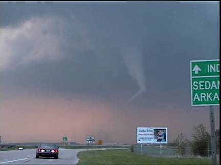
APRIL 19, 2000 –
HAVANA,
KANSAS
(TAFT PRICE/DAVID WILLIAMS)
A photo from my early days of chasing, this
was a bolt of lightning striking a shrub in Union
County, New Mexico.
Why? There are no trees. This chase covered 1100 miles and 21 hours. I arrived
back home in eastern Oklahoma
at 6:30am,
and can honestly say that it was quite a long trip for lightning.
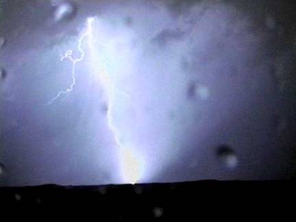
JUNE, 1997 – UNION
COUNTY, NEW
MEXICO (JON SLATER/DAVID WILLIAMS)
Another photo from Kingman County, Kansas – the 1st
tornado of the day on May 16, 1999.
MAY 16, 1999 –
KINGMAN COUNTY,
KANSAS
(TAFT PRICE/DAVID WILLIAMS)
Wall cloud from a Meade, Kansas
LP supercell. One reason that this storm (located in
a low moisture environment) was so visually awesome was because it went up
within the center of a deep surface low pressure system. This storm supposedly
produced the only tornado in the Oklahoma
Panhandle in 1997, but we only noted small funnels never approaching ground
level.
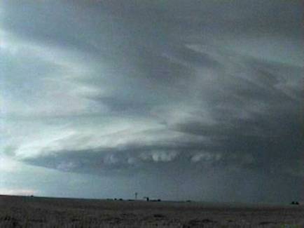
JUNE 15, 1997 –
MEADE,
KANSAS
(TAFT PRICE/DAVID WILLIAMS)
A frontal passage on May 11, combined with
strong surface heating and high dew points, spawned severe thunderstorms during
the late afternoon hours in eastern Oklahoma.
While no tornadoes were logged by the National Weather Service, a rotating supercell near Chouteau produced funnels that may have
briefly reached the ground.
MAY 11, 1999 – LOCUST GROVE,
OKLAHOMA (DAVID WILLIAMS)
RETURN
HOME
QUESTIONS? COMMENTS? SEND EMAIL
TO djw@members.asce.org.
©
DAVID J. WILLIAMS 2002. ALL RIGHTS
RESERVED.